
The 1 : 5 Million International Geological Map of Europe and Adjacent Areas (IGME 5000) shows the pre-Quaternary geology of the entire Europe onshore and – first time at this scale – offshore.
In addition to the age and lithology of the geological units also faults and structures, magnetic anomalies, the continental shelf and slope, the mid ocean ridge axis, metamorphic features, ophiolites and other geological features are shown.
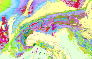
Extract from the IGME 5000 showing the Alps and parts of the Ligurian and Adriatic Seas.
The project was managed and implemented by the Federal Institute for Geosciences and Natural Resources (BGR) under the auspices of the CGMW (Commission of the Geological Map of the World).
The project involved geological survey and research institutes from 48 European and adjacent countries and the area covered reaches from the Caspian Sea in the east, to the Mid-Ocean Ridge in the west, and from Svalbard in the north to the southern shore of the Mediterranean Sea. The aims of the project were to develop a GIS underpinned by a geological database, and also a printed map providing up-to-date and consistent geological information. The printed map was published in 2005, the first web version in 2006.
The project was depending on the numerous contributions of the many participating countries. This required meticulous preparation and establishment of standards and protocols in order to provide the essential structure and guidelines for the data compilation, i.e., common vocabularies, portrayal rules, short notations and a guideline / description as to how create the national contributions. In addition, a standard topographic base map was an essential prerequisite. So in many areas the IGME 5000 established basic standards where none exist at that time.
Ultimately, the IGME 5000 GIS is showing the geological structure and composition of Europe without political boundaries at a small scale and provides a substantial foundation for geoscience projects and initiatives, such as EMODnet Geology, EGDI or GSEU.
The data are available as web map service and for download in both the original version and transformed according to the INSPIRE data specifications at the BGR Geoportal https://services.bgr.de/geologie/igme5000
and
https://services.bgr.de/inspire/igme5000eu
The IGME 5000 printed map is also sold in a reduced format at the scale 1:10 Million by the Commission for the Geological Map of the World.
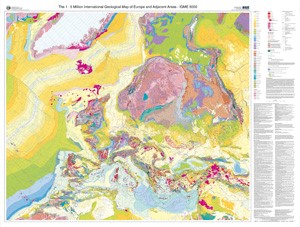
IGME 5000 print version sheet format.
Project facts:
Project duration: 1995 – 2006
Umbrella organisation: Commission of the Geologica Map of the World
Project coordination: Bundesanstalt für Geowissenschaften und Rohstoffe (BGR), Kristine Asch
Please visit also visit the BGR project web site https://www.bgr.bund.de/EN/Themen/Sammlungen-Grundlagen/GG_geol_Info/Karten/Europa/IGME5000/igme5000_node_en.html