IGME 5000 – International Geological Map of Europe
IGME 5000 is an international project aimed at producing a harmonised continental-scale geological map of Europe. It provides baseline geology information essential for understanding Europe’s geological structure and evolution.
The project integrates onshore and offshore geological data, including lithology, geological conditions and structural features. IGME 5000 supports research, education and policy development by offering a consistent geological reference framework.
The 1:5 Million International Geological Map of Europe and Adjacent Areas (IGME 5000) shows the pre-Quaternary geology of the entire onshore and offshore Europe for the first time at this scale. In addition to the age and lithology of the geological units, faults and structures, magnetic anomalies, the continental shelf and slope, the mid-ocean ridge axis, metamorphic features, ophiolites and other geological features are shown.
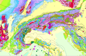
Extract from the IGME 5000 showing the Alps and parts of the Ligurian and Adriatic Seas.
The Federal Institute for Geosciences and Natural Resources (BGR) managed and implemented the project under the auspices of the CGMW (Commission of the Geological Map of the World).
The project involved geological surveys and research institutes from 48 European and adjacent countries, and the area covered reaches from the Caspian Sea in the east to the Mid-Ocean Ridge in the west and from Svalbard in the north to the southern shore of the Mediterranean Sea. The project aimed to develop a GIS underpinned by a geological database and a printed map, providing up-to-date, consistent geological information. The printed map was published in 2005, and the first web version was published in 2006.
The project depended on the numerous contributions of the many participating countries. This required meticulous preparation and the establishment of standards and protocols to provide the essential structure and guidelines for data compilation, including standard vocabularies, portrayal rules, short notations, and guidelines/descriptions for creating the national contributions. In addition, a standard topographic base map was an essential prerequisite. So, the IGME 5000 established basic standards in many areas where none existed.
Ultimately, the IGME 5000 GIS shows Europe's geological structure and composition at a small scale, without political boundaries, and provides a substantial foundation for geoscience projects and initiatives, such as EMODnet Geology, EGDI, and GSEU.
The data are available as a web map service and for download in both the original version and transformed according to the INSPIRE data specifications at the BGR Geoportal https://services.bgr.de/geologie/igme5000
and
https://services.bgr.de/inspire/igme5000eu
The IGME 5000 printed map is also sold in a reduced format at 1:10 million by the Commission for the Geological Map of the World.
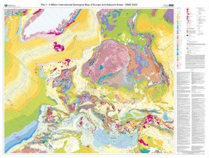
IGME 5000 print version sheet format.