If you have useful data (map layers, geological models or unstructured documents), which you would like include in EGDI, we will be pleased to tell you how to show them in our platform.
The EGDI platform handles basically three kinds of material:
If you have material of one of these types, which you would like include in EGDI, you should start by contacting the EGDI Operations Group at contact@europe-geology.eu. You will then have a dialogue with the group about your data, how they will be best represented on the system, formats, etc.

Map layers can be included in EGDI in two fundamentally different ways. Either by uploading a GIS file (Shape file or GeoPackage) or by registering an OGC webservice (WMS or WFS). In both cases it is required that some metadata information is registered in the EGDI metadata catalogue before the layers themselves can be uploaded or registered. You can find a users guide to the metadata catalogue here.
Once the metadata information is entered you can start uploading your GIS files or registering your services. A users guide to this can be found here.
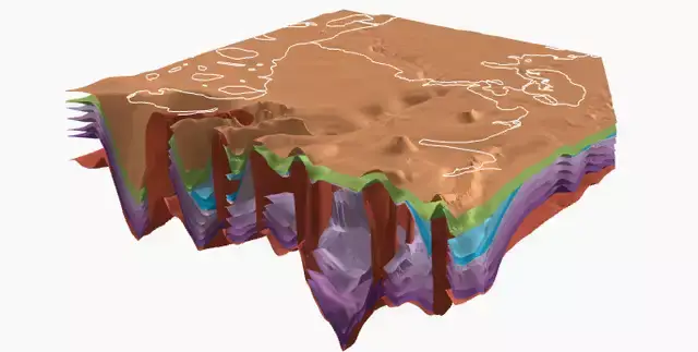
3D geological models can by uploaded to EGDI in several different formats (GoCad TSurf, Wavefront Obj files, ZMap Plus Grids, ESRI Ascii Grids, GeoScene Grids and as comma separated files). The models can be uploaded and stored in the central EGDI 3D database. A users guide to this can be found here.

Unstructured data can be uploaded as pdf files, png, jpeg and CSV files or an identifier for the data (for instance a DOI) can be registered. A users guide to this can be found here.
Dive into the EGDI tools that provide a more specific functionality. Go to our Document Repository to search for and access geological documents with advanced search options and filters. Explore our Vocabularies to understand the semantic relationships between key geological concepts, supported by codelists and real-world entity mappings. Utilize our Multilingual Keyword Thesaurus to enhance the discoverability of datasets through consistent keyword assignments. Access standardized metadata via our Metadata Catalogue, empowering informed decision-making and collaboration. Lastly, explore Map Services and Layers to gain insights into available map layers and corresponding web service status. With these tools, you’ll streamline your geological exploration and analysis, uncovering valuable insights with ease.
These tools complement and assist in the exploration and documentation of data and services.
Email the helpdesk with any questions/issues: support@europe-geology.eu.
NOTE: This automatically adds your enquiry to our public issue tracker https://support.europe-geology.eu/
Other interesting links:
eLearning resources
GeoERA issue tracker
GeoERA Data provider support